
The Beginning of Newton East, Part Two
New Zealand historian and author Lynnie Howcroft researches the early days of Uptown.
‘Advance Auckland!’ was declared in an article in the 1862 New Zealander, celebrating the spectacular prices that the subdivisions in the Newtown gully had achieved. What an encouraging sign this would have been to the early European settlers! Auckland, the expanding capital city of New Zealand, was proving to be worthy of their time, energy, and investment. (14 May 1862 New Zealander Issue 1677 page 2)
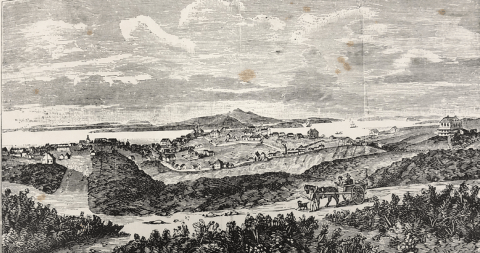
In reality Auckland’s town in 1862 was not physically ‘advancing’ too far. The town’s southern border ran along the north side of Karangahape Road while Newtown’s northern boundary ran along the south side of Karangahape Road. Perched on the the city side of this road stood the iconic Partingtons windmill built in 1850, and St Keven’s house that enjoyed the magnificent views across the Waitemata Harbour. Opposite Partington’s windmill, on the south side of Karangahape Road was the Symonds St Cemetery.

Partington’s windmill on the Karangahape Road ridgeline. Around the cluster of trees on the ridgeline was the site of St Keven’s house.
Sir George Grey Special Collections, Auckland Library AWNS -190000928-4-7
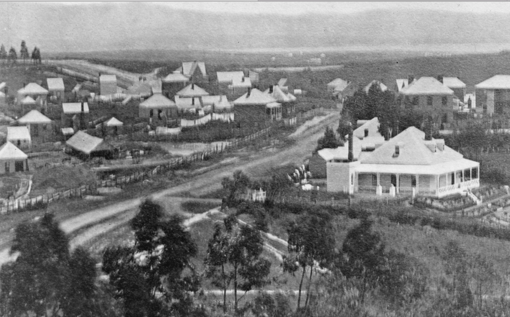
1850’s - Views to the Manakau Harbour from Karangahape Road. The scrub to the left of the cart was the gully’s northern border.
The gully offered the early settler in the 1850’s an opportunity to own blocks of land that were close to Auckland’s town. The original gully’s landowners who had purchased off the Crown had had a measure of success working their land. Some had built their homes and owned chooks, pigs, cows, and orchards that produced peach, apple and figs. Some grazed livestock or grew oats. Others had made bricks out of the gully’s clay to meet the demand for building material needed in Auckland’s burgeoning town. But, despite the hype and attention given regarding the profit made from their subdivisions, changing the use of the gully’s pitted clay slopes from farmland to surveyed lots proved to be difficult. An old timer who lived in the gully remembers walking down Upper Pitt St (Mercury Lane) to the base of the gully (now the center of the Newton Motorway Interchange) then up to the rise of East St (Ian Mckinnon drive), ‘…Required not only great sobriety but a determined will...’
The original owners therefore took a gamble when they surveyed their land and used their own capital to do so. Their bet was that their land would satisfy the new setttler’s demand for affordable parcels of land that were close to the city, even if it meant buying and then building in a gully.
The first to take this gamble was the Hawkes Bay politician, Mr Stark, in 1858. His development formed North, South, East and West Streets. It was here that the suburb of Newtown (Newton East) began to form.
One year later, on the opposite side of the gully Mr Ashton subdivided his land. He was once was a London merchant, and now in New Zealand he sold imported drapery on Queens Street. Possibly he had bought the block of land off the Fairburns when William died in 1859. This land had been divided into 70 allotments sown in clover on the North side of Newton Road. By 1860 Ashton had turned three acres of oats into sections on Randolph, Oxford (France St) and Duke (Karaka) Streets.
Remaining streets including Cargill, Regent and half of Montague Street were formed and sold over the next two years.
St Benedict Street too (then called Albert St) was subdivided in 1859, but had only extended to the Fairburns land.
By 1860 Mr George Turrell who had built a grocery shop in Newton Road was next to sell the 50 allotments that adjoined his property.
The auctioneer hammer fell again for Mr Burns, a newspaper editor who lived in Emily Place in 1862. He sold his second subdivision named Cotele on the corner of Newton and Upper Symonds Street, along New North Road and then down into the gully, forming Basque Road, Exmouth and Dundonald Streets. A substantial house on the site where the Upper Symonds St community gardens are now was included in this sale.
Newtown, now referred to as Newton, had caught the attention of the investor. A buying frenzy occurred when Messers Laurie’s land that fronted onto Karangahape Road, and formed Cross, Upper Queen, and Easts Streets selling in the same year as Mr Burn. Despite the creek that ran through part of Upper Queen St to the back of Cross St, almost all of the Laurie’s 100 allotments had sold. The Laurie’s exchanged their Steam brick Factory, for a huge profit, and moved their business to Glendene.
1862 : Photo - Looking west from Partington’s windmill along Karangahape Road (in the center), to Waitakere ranges. Queen St is not formed.
- Right hand side of the road, in front, is St Keven’s house. Had been Auckland Boys Grammar, now the military headquarters for Lieutenant General Cameron Duncan
- The Naval Hotel is on the corner of Pitt St.
- On the left side of Karangahape Road, at the front, is Messrs Laurie’s land, 100 lots sold in1862. Their Auckland Steam Brick Factory and water can be seen.
- Behind Laurie’s land is Mr Stark’s subdivision, Newtown. East, West, North and South St’s were subdivided in 1858, and built on. Washing lines are full!
Spurred on by the capital gain and rapid number of cottages that had been built in the gully over the last five years, the next ‘Subdivision 10’ sold in 1863. Fronting onto Karangahape Road, this land adjoined Mr Starks, West Street, and formed Edinburgh and Dublin St’s (now Cobden). Running through the middle was London St (now Ophir St). The sale occurred in the same month as Lieutenant General Duncan Cameron led British troops to cross the Mangatawhiri stream, (the aukati line imposed by King Tāwhiao Tūkāroto Matutaera Pōtatau Te Wherowhero after the Northern Taranaki War in 1861). This deliberate provocation ordered by Governor Grey was intended to incite war in the Waikato, with the sole intension to suppress the Kingitanga movement. It seems however, that this tragic event did not dampen the Subdivision10’s sales.
As the war in the Waikato intensified the center of the gully was ready for sale the following year. Owned by the Premier of New Zealand (Prime Minister) Mr Whitaker, the term 'Advance Auckland!’ was also used as the headline to advertise the sale of his126 allotments in the New Zealand Herald. This time this term was used to alert the early settler investors to the ‘wonders of living in Newton’. Whitaker’s ability to mix politics with business is evident. Quite an achievement to create a new subdivision while leading a government initiative of war .
By 1865 the Waikato war had ended with the Kingite Māori being pushed into the King Country. The result of the war for Auckland was a struggling economy. At the same time its boast of being the capital city that hosts Parliament had been handed to Wellington. Business savvy Mr Probert responded to this crisis by leasing his subdivision allotments for a period of 21 years. With no outlay to buy the land, the purchaser was only required to fund the cost of building a home. Probert’s land was on the west side of Newton Road running down to the base of the gully. The land fronted on the corner of Great North and Karangahape Road and formed Nixon, Burgoyne and Chapman Streets.
Mr Morrin, subdivided in this year also, but sold 45 allotments. He formed Canada St, joining Upper Queen Street at each end, linking the road to both the Lauries and Whittakers subdivisions.
The last two subdivisions occurred after the Karangahape District and Highway Boards had been formed which allowed the Newtonians to collect rates, manage their own roads, and infrastructure. When the Gundry family divided their land in 1873 the Karangahape Board contracted the carters to form the roads and the footpaths.
Sadly the last of the Gully owners Jane Fairburn had died before she could benefit from the capital gain made when her land was sold in 1884. Her land fronted the corner of Newton Road and Upper Symonds St, and formed Gladstone Street (now St Benedict Street) that joined St Benedict St to Newton Road.
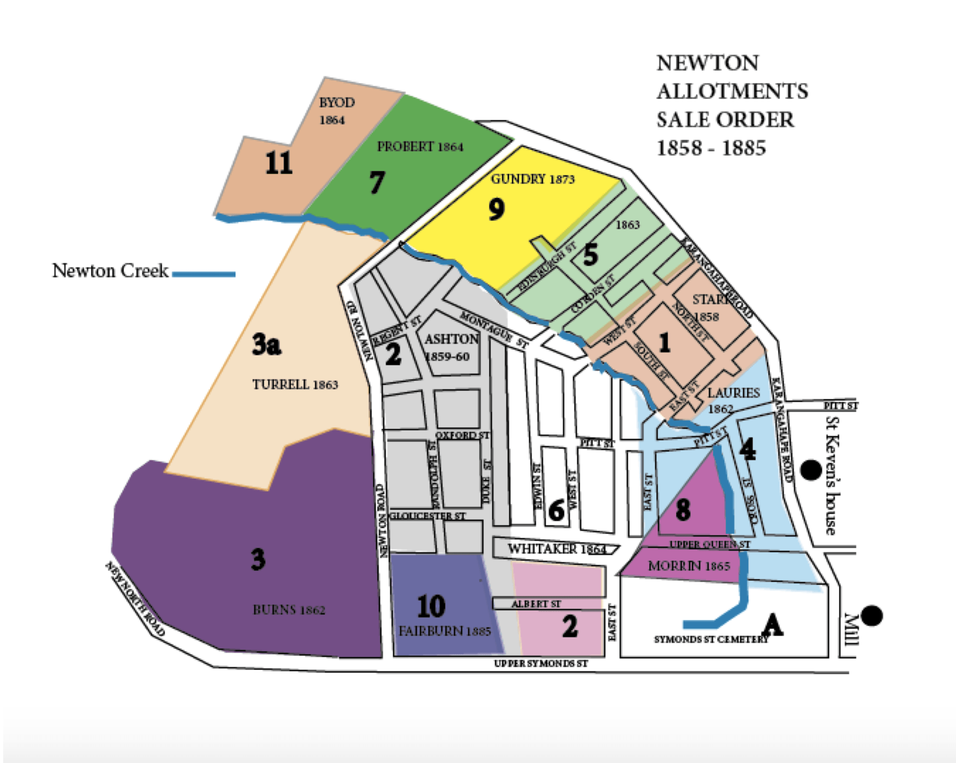
ORDER OF GULLY SALES
Section 7 Allotments 1 - 13
A) Cemetery
- 1858 Mr Stark, Allot 9
- 1859 Mr T Fairburn Estate Allot
1860 Mr Herbert Ashton, Allot - 1858 Mr David Burn, Allot 1
1862 Mr David Burn, Allot 2 - 1862 Laurie clan, Allot 8
- 1863 Section 10 sale, Allot 10
- 1864 Mr Frederick Whitaker, Allot 6
- 1864 Mr John Probert, Allot 12
- 1865 Mr William Morrin, Allot 7
- 1873 Mr Gundry, Allot 11
- 1885 Mrs Jane Fairburn Allot 3
Mr George Boyd Allot 13 merged into Newton West
The original Newton gully owners took a gamble to subdivide their land., but enjoyed a healthy capital gain for their efforts. The early European’s thirst for land far outstripped any common sense regarding how difficult it would have been to live in a gully, and the economic fall out of living in Auckland after the war.
Click the buttons below to learn more about the people who bought this land.